INTERNATIONAL GEODESIGN COLLABORATION
The International Geodesign Collaboration (IGC)
The International Geodesign Collaboration (IGC)
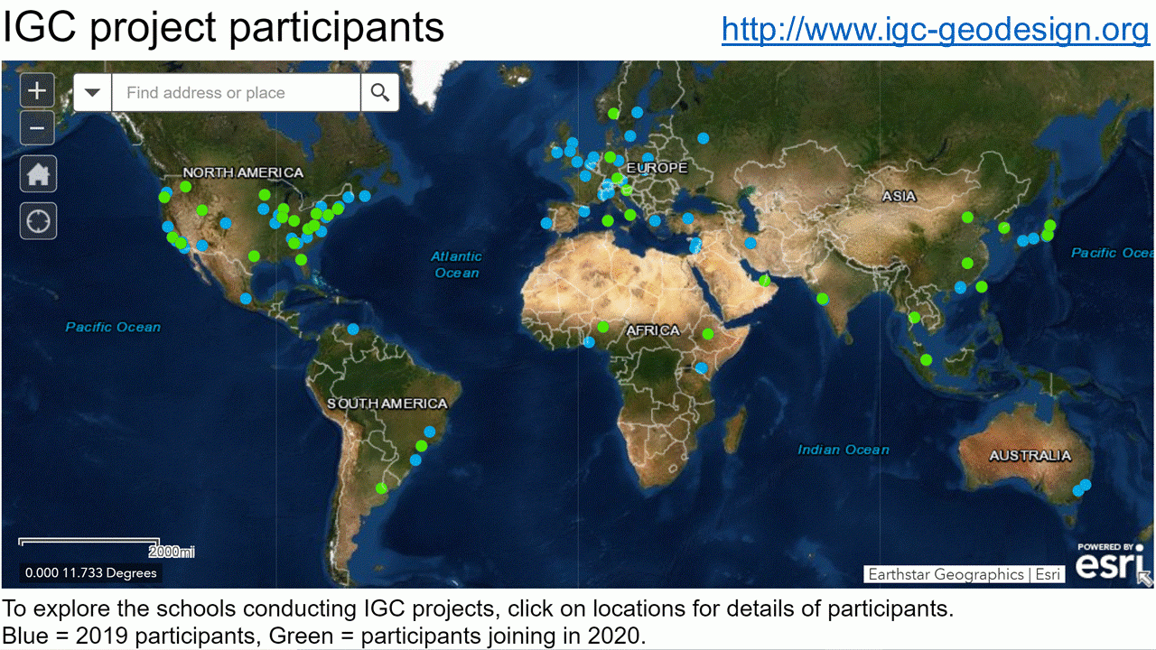
Improving our Global Infrastructure: The International Geodesign Collaboration Brian Orland 2, Carl Steinitz 3 2 The University of Georgia, United States borland@uga.edu 3 Harvard Graduate School of Design, United States; University College-London, UK.
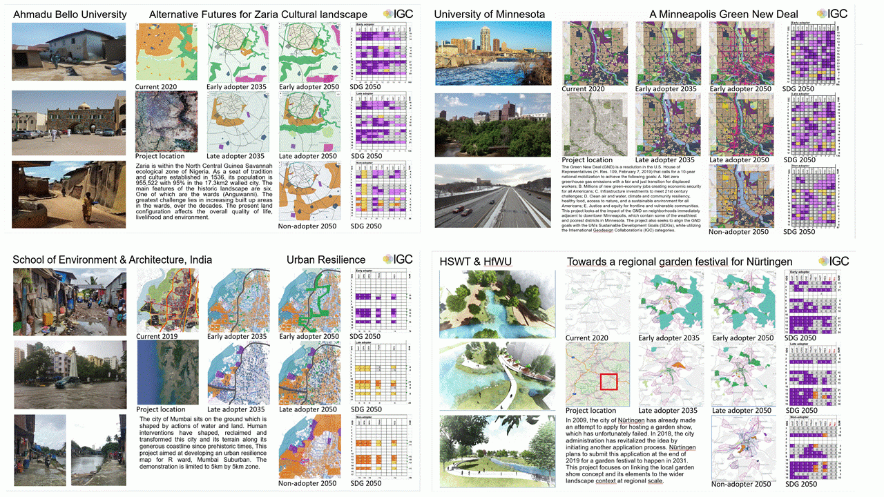
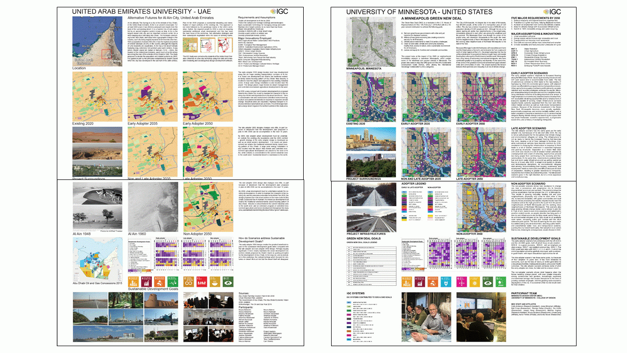
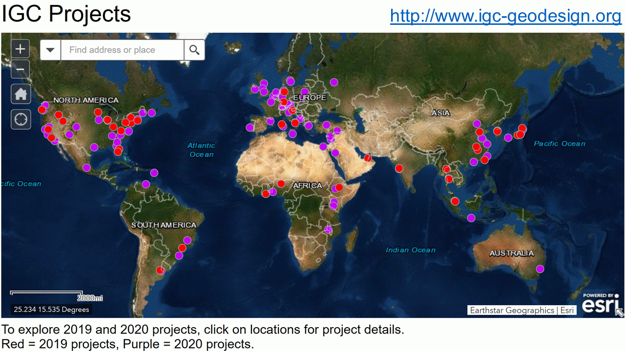
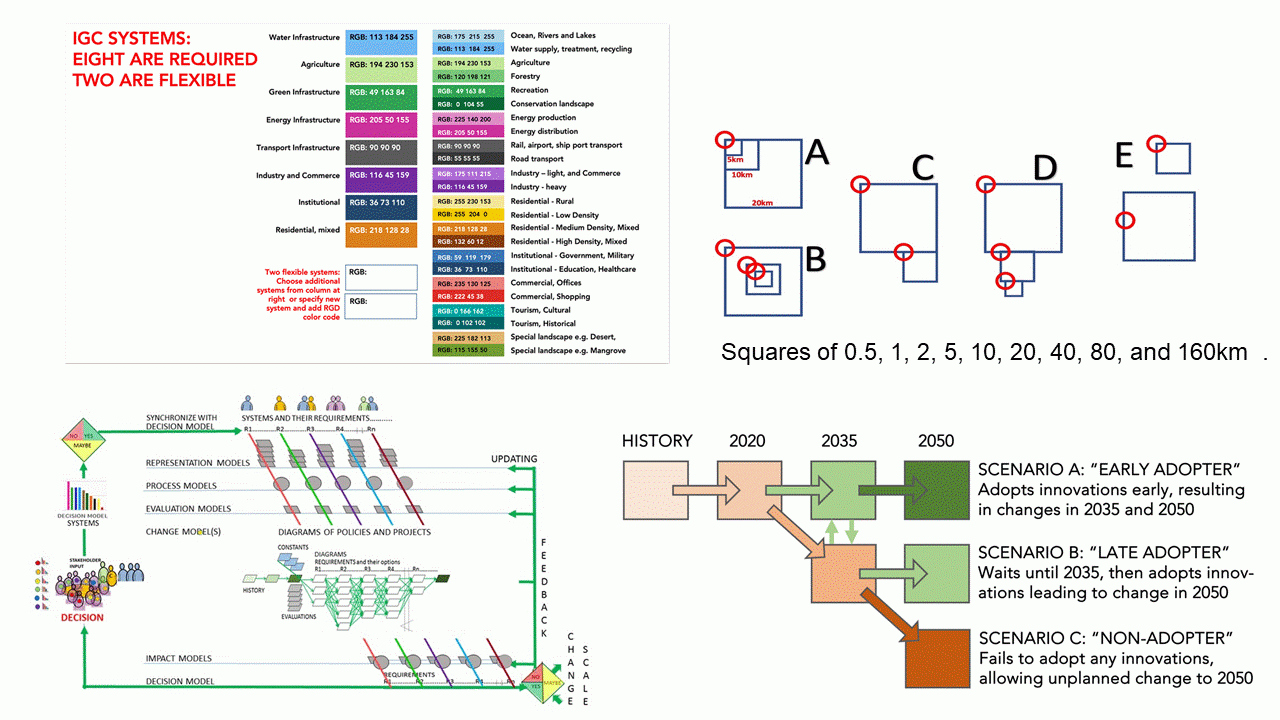
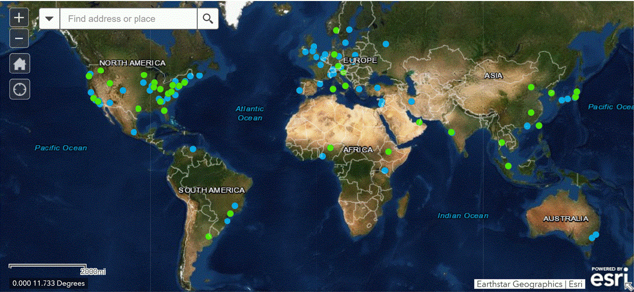
The world faces a generic but critical challenge: How do we organize and conduct the very beginning and strategic stages of designing for longer-term changes in large, multi-system, multi-client and contentious contexts? This is a severely under-recognized problem when we face crisis, risk or uncertainty—the most common conditions of our biggest societal challenges. Geodesign (design at geographic scale) represents an emerging design research and practice approach that integrates multiple disciplines and uses geographical infor-mation systems (GIS)-based analytic and design tools to help explore alternative future scenarios (GOODCHILD, 2010; GU, DEAL & LARSEN, 2018; RIVERO ET AL., 2018; STEINITZ, 2012). The focus of the International Geodesign Collaboration (IGC) is academic, to understand better how geodesign can be applied to addressing design challenges in settings that are widely dispersed, differ widely in scale and in the extent of resources (skilled people and prepared data) available to find geodesign solutions. We are driven by a specific and ex-ceptionally complex problem: How do we identify and share the lessons and practices developed by a globally-dispersed array of experts so that the resulting knowledge can be leveraged to solve our most pressing societal needs? We know that the solutions will call for deep integration across the traditional expertise residing in the physical, natural and social sciences, but they will be articulated through the landscape- and city-shaping of planners, designers and engineers. We are interested in how multi-disciplinary teams in multi-institutional and multi-national groups consider and respond to the environmental, economic, and social impacts of development and change in natural and increasingly engi-neered systems. These include structural components such as cultural and governmental differences, but also the leadership skills of individuals, team construction, and communi-cation. The idea for the International Geodesign Collaboration was raised by Carl Steinitz at the Geodesign Summit conferences held at Esri headquarters in Redlands, CA, in 2015 and again in 2016. In January 2018 an agreement was made among Tom Fisher, Carl Steinitz, Brian Orland, and Ryan Perkl to organize the collaboration. By March 2018, by invitation and word-of-mouth, team-leading investigators from about 90 schools had joined the IGC. Many are landscape architects, but many are not. All had to form multi-disciplinary teams to accomplish the agreed tasks of the collaboration. Almost every university in the world studies these issues and is potentially in a position to propose improvements to our normal everyday social and environmental practices. Yet every university and every unit of government acts in its own set of geographies and socie-ties, and with its own content, definitions, methods, languages, color codes, and representa-tion techniques. It is extremely difficult to compare across institutions to learn from each other. This collaboration proposes a radical increase in sharing and in the standardization of communication so that sharing, comparison and mutual learning can take place much more easily. We believe that a central aspect of effective collaboration and eventual action is and will be public understanding of complex issues, and that this can be done without professional jargon, artistic obscurity and scientific myopia. Our goal for this endeavor was bold. We believe that there is need for a large number of people – perhaps 10,000 – in the next decade who are educated broadly about the state of the world and specifically about the analytic and synthetic methods in order to propose change for the betterment of society and the environment in the face of inevitable global change. The most efficient way is to educate today’s university students in these matters and to do it in a manner that enables collaboration and mutual learning inside the universi-ty, and across institutions and nations. Project Structure Our key observation driving this project was that while the object of attending international meetings is to learn from the experiences of others, our methods of sharing obscure rather than enable that purpose. Participants use their own idiosyncratic layouts of information, the elements chosen to highlight specific items of local interest. They use graphical and cartographic conventions that are determined by either national standards or by personal preference. Project areas can be simple rectangles but are usually complex polygons, sometimes but not always including a “context” buffer of surrounding landscape influenc-ing and influenced by the project. While the expressed intent may be to solve problems with global consequences, they rarely reveal the assumptions made about the future, nor the design innovations that address the emerging needs. In order to learn by comparison between projects it was evident that some organizing principles must be imposed so that different projects expressed the same ideas in the same ways. To achieve this, the IGC imposed some compositional rules: a) Select one or more square study areas corresponding to a scale of standard sizes (0.5km x 0.5km, 1 x 1km, 2 x 2km, 5 x 5km ... 160 x 160km) (Figure 2). b) Adopt pre-researched global change assumptions based on the international governmental and NGO projections. c) Adopt nine standard and one optional resource systems as the basis for design (e.g., green infrastructure, transportation, energy infrastructure etc.) (Figure 3a). d) Select and implement innovations addressing the nine resource systems. e) Apply three scenarios, early-, late-, and non-adopters of design changes, and re-port the impacts at three time-steps, 2020 (existing), 2035, and 2050. (Figure 3b). Participants were also asked to make a series of organizational commitments: Organize their own technological support, a, and apt systems data and models to their own local conditions, and present all results in a common graphical format, in English, Method The IGC global assumptions and projected systems innovations for 2035 and 2050 were prepared by IGC research groups. We identified nine systems that are fundamental to ge-odesign. Based on preferences stated by participants we identified groups for each system, and a leader for each group. Each of the system groups researched innovations and strate-gies that are likely to occur by 2035, and others by 2050, that may offer design and plan-ning benefits to all participants. A Microsoft Powerpoint-based format was developed to illustrate and share ideas; each participant would choose whether to adopt particular inno-vations for their project, and how to design or plan for them. The key elements of an inno-vation description are a title, a brief description, key website URLs and illustrations, properly credited. These are available as an on-line library at http://www.geodesigncollab.org. The global assumptions and system innovations describe ideas that may be relevant to particular pro-jects, but they were not relevant or required for all projects. Recommendations for specific outcomes or goals were not included; however, each assumption and innovation was writ-ten with the knowledge that individual nations and municipalities would scale and parame-terize assumptions and innovations to their specific geodesign project. Participants were able to define their own projects within the constraints identified in sec-tion 2 above. Via the generosity of Esri and Geodesignhub.com, schools were able to ac-quire software and some minimal support for a range of key tools at no cost. At the most fundamental level, one of the key steps in making comparisons between pro-jects is the ability to compare like with like. Accordingly, to compare IGC outcomes either as traditional wall display posters or as pages in a publication, all participants were required to follow a graphic layout format based on the consistent square-formatted project loca-tions (Figure 6). Other key elements for presentation included lists of the focal global assumptions for the project and the most important system innovations adopted. As before, all project submissions are available via http://www.geodesigncollab.org for viewing, ma-chine translation and download. 2 Project Outcomes Ninety-one schools applied to join the IGC. As expected, a range of political, personal and financial issues intervened, and 55 schools finally submitted completed projects. Partici-pants from 40 of those schools were able to attend the IGC 2019 meeting and present their projects. In addition to project presentations, attendees participated in four discussion groups addressing questions generated by the IGC process and exploring the future shape of IGC-like meetings, including the prospect of a second meeting, in 2020. Two of the discussion topics examined the constraints placed upon project participants—the necessity to adhere to a pre-defined and generic set of resource systems, and the adoption or not of global assumptions and system innovation. A third topic asked a more general question about how the methodological and technical organization of IGC and its processes might have shaped the designs, and, finally, the fourth discussion asked whether the IGC initia-tive had been useful and should be repeated. 3 Conclusion and Discussion In the ten years since the first Geodesign Summit hosted by Esri at their headquarters in Redlands, California, and in Geodesign Summits in Japan, China, Brazil, The Netherlands and other geodesign-related conferences like DLA, we have collectively seen hundreds of geodesign presentations, viewed thousands of poster presentations and read books of ge-odesign guidance including STEINITZ’ 2012 A framework for geodesign and MCELVANEY’s 2012 Geodesign: Case studies in regional and urban planning. In no cases, however, has it been possible to make direct comparisons among projects—each one has stood alone with its idiosyncratic assumptions, chosen design scenarios, analytical ap-proaches and graphic styles. In contrast, the participants in IGC were required to agree to follow a common format. The results of this first collaboration can be viewed and down-loaded at http://www.geodesigncollab.org. In those cases where the guidelines were closely followed, participants could compare the global assumptions prioritized by European vs. Asian participants, the system innovations targeted by African vs. North American partici-pants. They could compare the extent of change effected at 2035 and 2050 by participants working in urban vs. rural settings or on high latitude vs equatorial projects. It is as yet early days for comprehensive findings from the submitted projects. The IGC meeting provided opportunities to share experiences among participants at a depth of understanding newly available because of the design process and reporting constraints adopted by project teams. The success of that small advance alone has ensured the continuation of the IGC organization and a second meeting in 2020. We anticipate many other university teams will join this growing collaboration in geodesign. Acknowledgments IGC is largely a volunteer effort. The core steering committee for IGC-2019 comprised Carl Steinitz, Brian Orland, Tom Fisher of the University of Min-nesota, Ryan Perkl of Esri and Mike Gould of Esri. Valuable technical support came from Esri and Geodesignhub.com. Maggie Dunlap provided invaluable administrative support. Esri generously hosted the first IGC meeting in Redlands, California 23-25 February 2019. The University of Georgia and the University of Minnesota provided additional financial support.
References GOODCHILD, M.F. (2010) Towards geodesign: Repurposing cartography and GIS?. Cartographic Perspectives. 66: 7-22. GU, Y., DEAL, B., AND LARSEN, L. (2018). Geodesign Processes and Ecological Systems Thinking in a Coupled Human-Environment Context: An Integrated Framework for Landscape Architecture. Sustainability, 10 (9): 3306. MCELVANEY, S. (2012) Geodesign: Case studies in regional and urban planning. Esri Press, Redlands, California. RIVERO, R.G., SMITH, A., BALLAL, H., STEINITZ, C., ORLAND, B., MCCLENNING, L. AND KEY, H. (2018) Experiences in Geodesign in Georgia, USA. DISEGNARECON, 11 (20): 14-1. STEINITZ, C. (2012) A framework for geodesign. Esri Press, Redlands, California.
The International Geodesign Collaboration (IGC) was started by landscape architects in 2018 and now has 140 university teams, most but not all led by landscape architecture faculty. We have 96 completed local-to-regional studies, all in 2020-2035-2050 scenarios and within similar sets climate and demographic-driven global assumptions, and all in the same design language. Please see https://www.igc-geodesign.org/ and the attached paper, and especially https://www.igc-geodesign.org/igc-2019-completed-projects and also https://www.igc-geodesign.org/2019-20-projects in which all are assessed in the UN Sustainable Development Goals (SDGs). IGC is a volunteer organization with no budget, as every school is already (or should be) conducting such related work. IGC provides a way of sharing, comparing and learning. We encourage all universities to join IGC.