Parque Gonçalo Ribeiro Telles
Parc Gonçalo Ribeiro Telles
Gonçalo Ribeiro Telles Park
Objectives
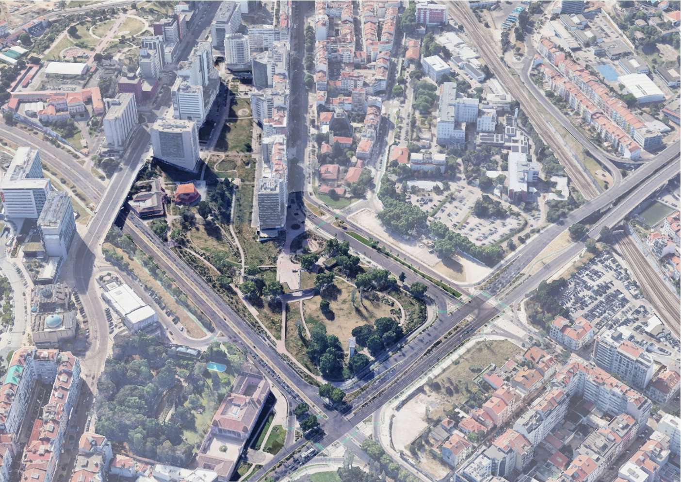
The Praça de Espanha Park (Gonçalo Ribeiro Telles Park), through its spatial, hydrological and transport centrality, can be the site of a new urban concept - a city built in relationship with nature rather than superimposed upon it. Where water's pathways return to the surface. To understand and value water as a finite resource fundamental to our existence. To take advantage of its presence by promoting the most productive landscapes that water knows how to create: lush and fresh riparian galleries, bringing nature to the city's doorstep and to the Gulbenkian Park.
• The urgency of expanding the connection between the natural system and the cultural system;
• Amplifying and consolidating the natural continuum within the city;
• Building according to aptitude. A park in the right place with the capacity to be so, given the morphological, hydrological, pedological and historical context;
• Designing in balance with nature, through understanding the material and temporal cycles of water and soil, plants and animals;
This location is one of the epicentres of Lisbon's largest drainage basin; most of the rainwater runoff from the Avenidas Novas plateaus passes through here towards the Alcântara Valley. The system has long been artificialized, with the watercourse piped and flows diverted. However, the potential to generate a singular ecosystem remained.
To renaturalise in coexistence with other urban systems, the water's pathway, promoting the installation of a humid ecosystem that is naturally biodiverse and productive, with all the benefits that follow: a more sustainable garden, a cleaner and fresher atmosphere, a city more resilient to climate change, and more beautiful.
Description
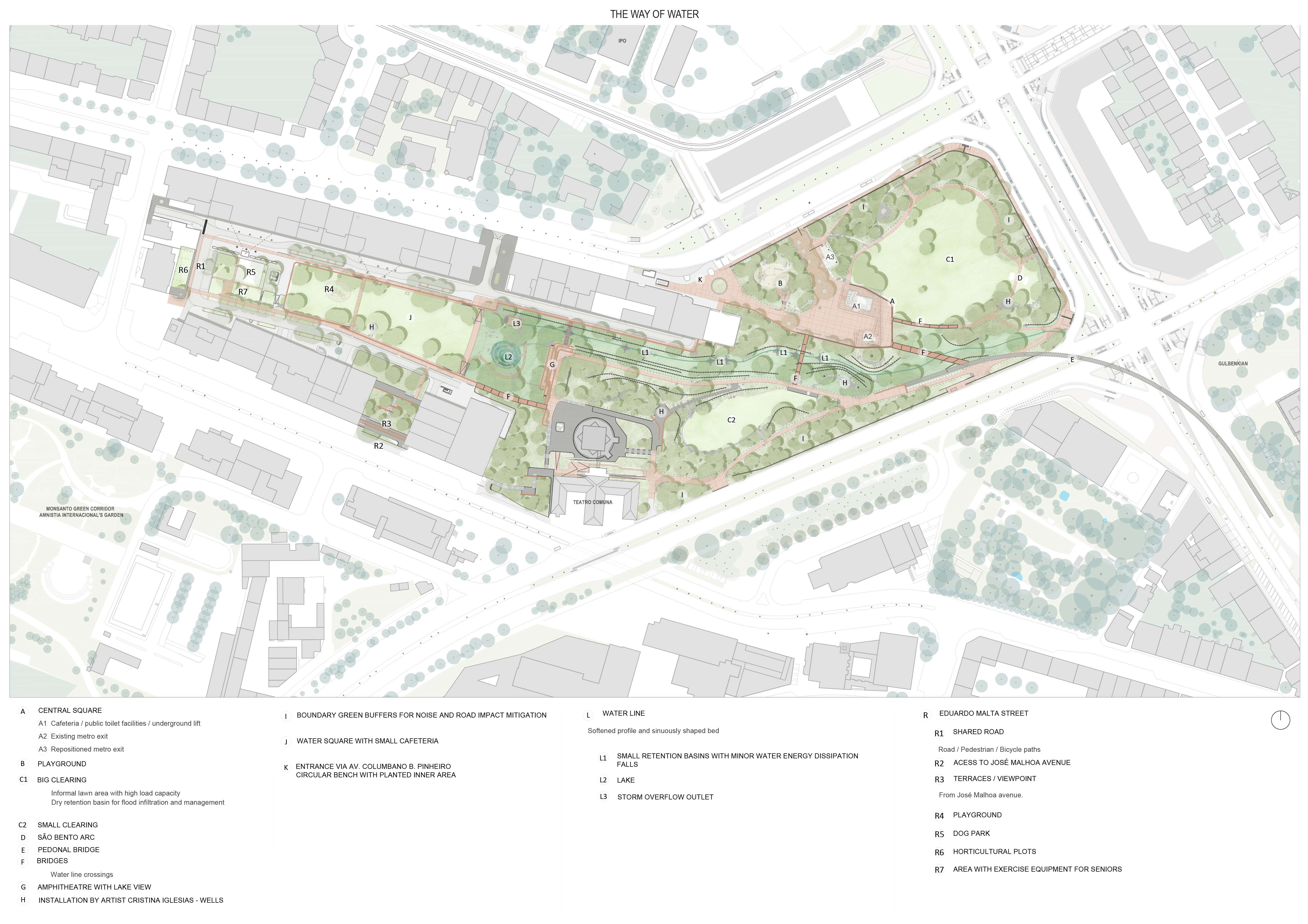
Fragmented spaces and places were aggregated, space was reclaimed from the road system, and hydrological, biological and pedestrian continuity was re-established across an area of 6.5 hectares.
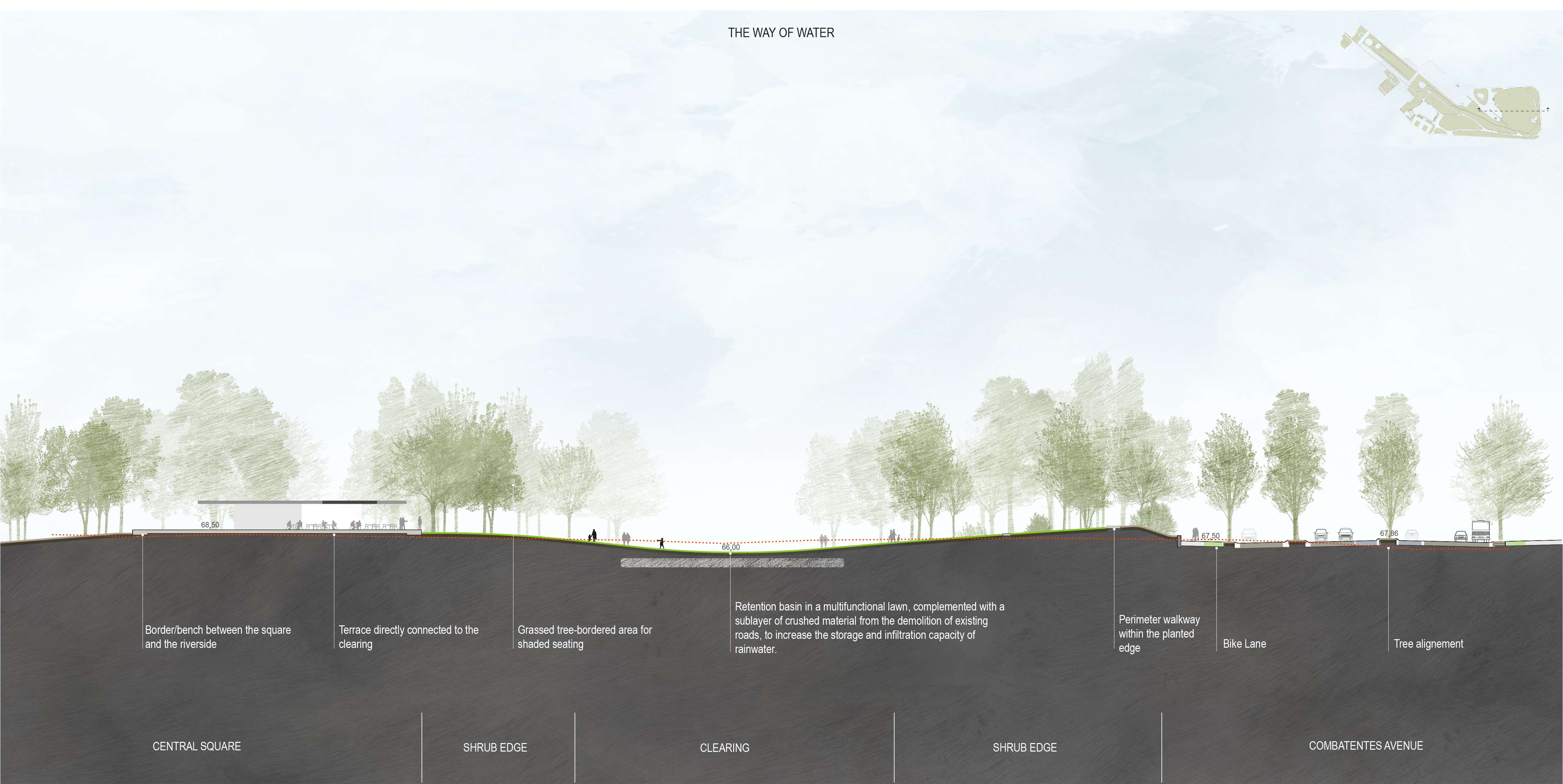
The park's centre is dual, integrating the Great Clearing and the Central Square - two intensively used places of contrasting natures that complement each other, together forming an immense place of encounter, stay and orientation.
Parallel to the water's pathway, pedestrian and cycling mobility was reinforced, oriented and universal. Firstly, crossing the stream with a great diagonal that establishes a new connection between the consolidated city centre and the neighbourhoods to be consolidated to the north. Secondly, developing a matrix of paths that feeds the park's interior and promotes access between neighbourhoods.
Collaboration with artist Cristina Iglesias
In collaboration with the artist Cristina Iglesias, a series of fountains/wells (4) unveil the secret river, allowing us to witness and hear it. The fountains seem to draw water from the riverbank that passes beneath. This allegory is crucial to conveying the idea that it is possible to see the water at the surface again.
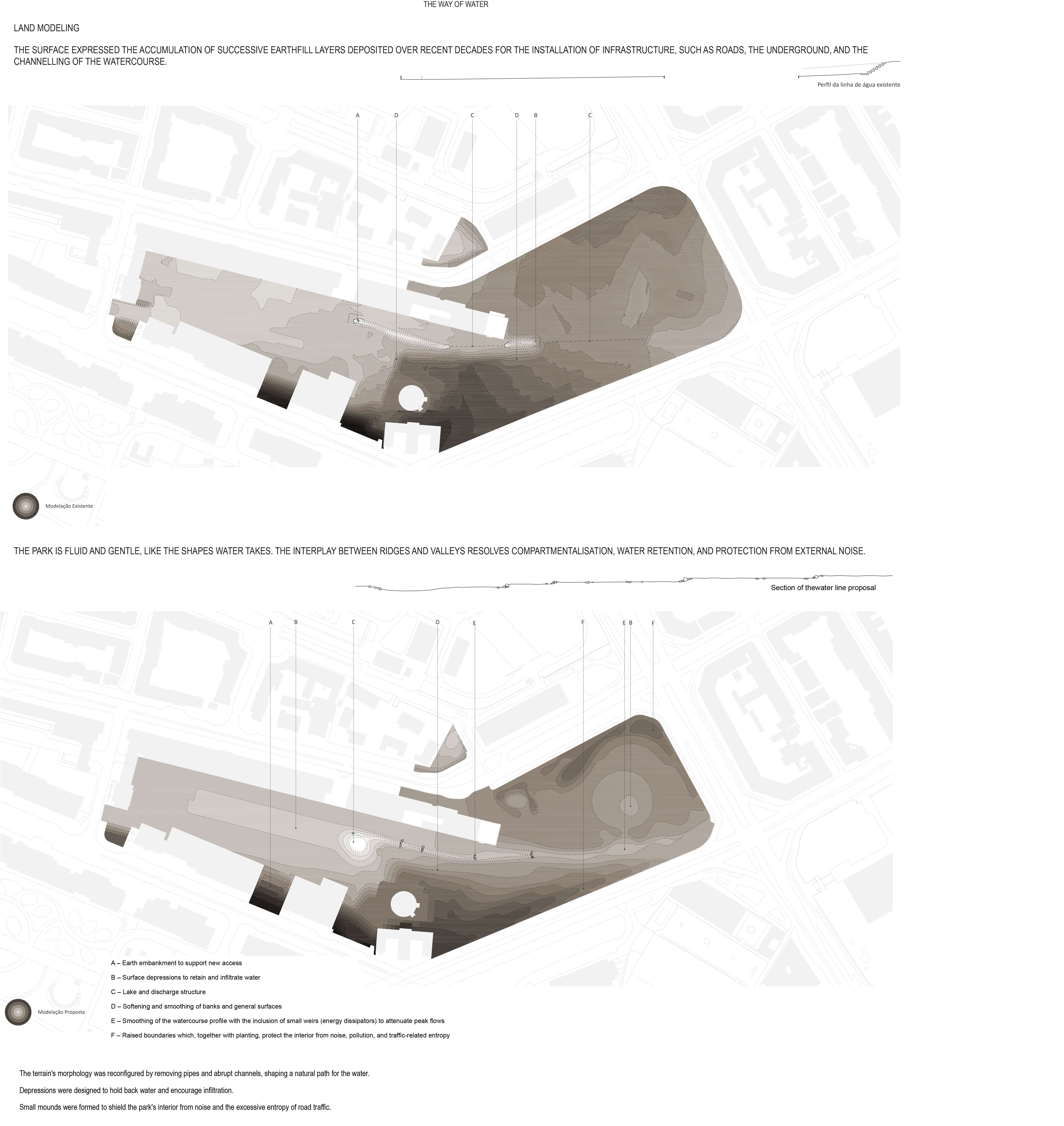
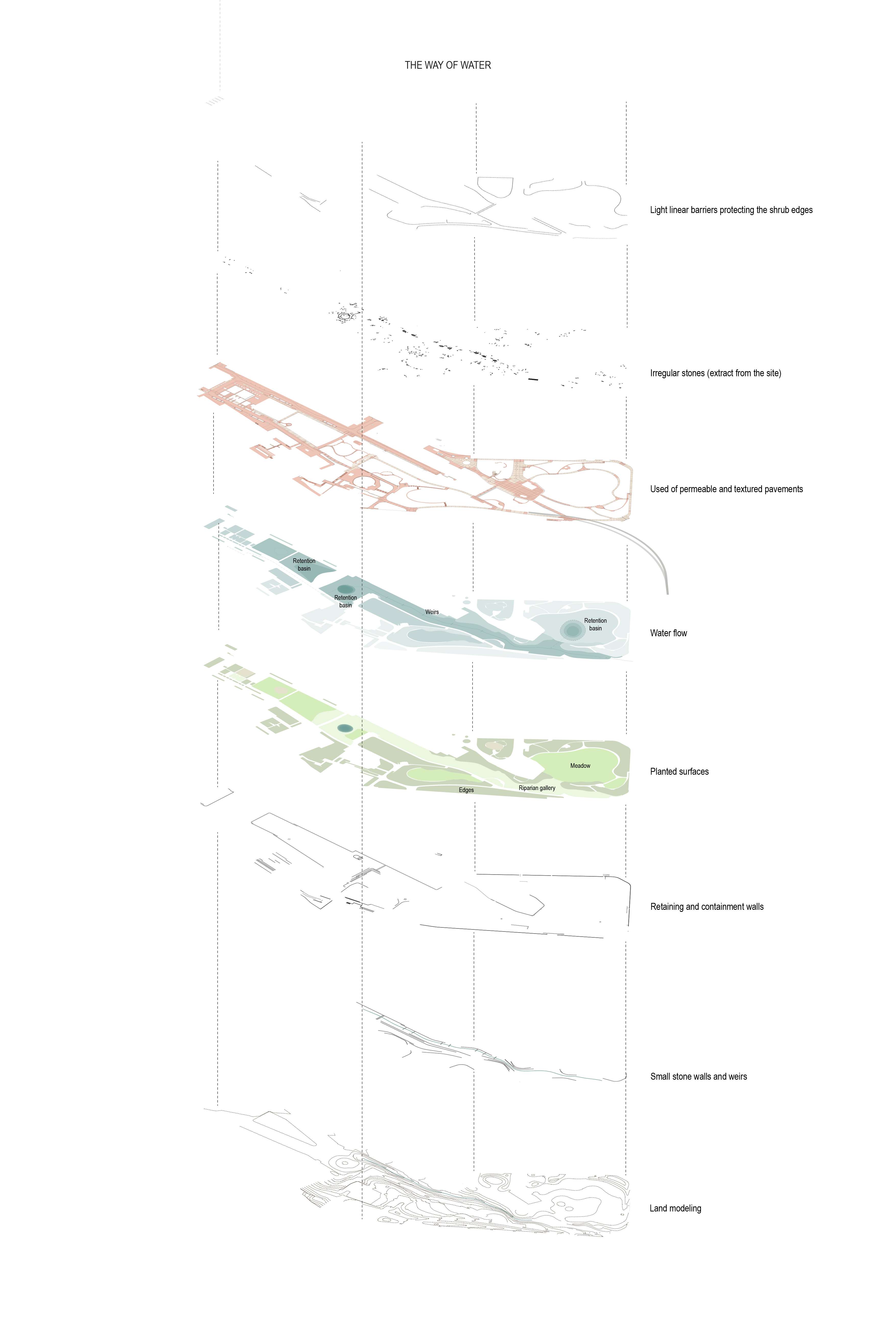
Modelling Solution
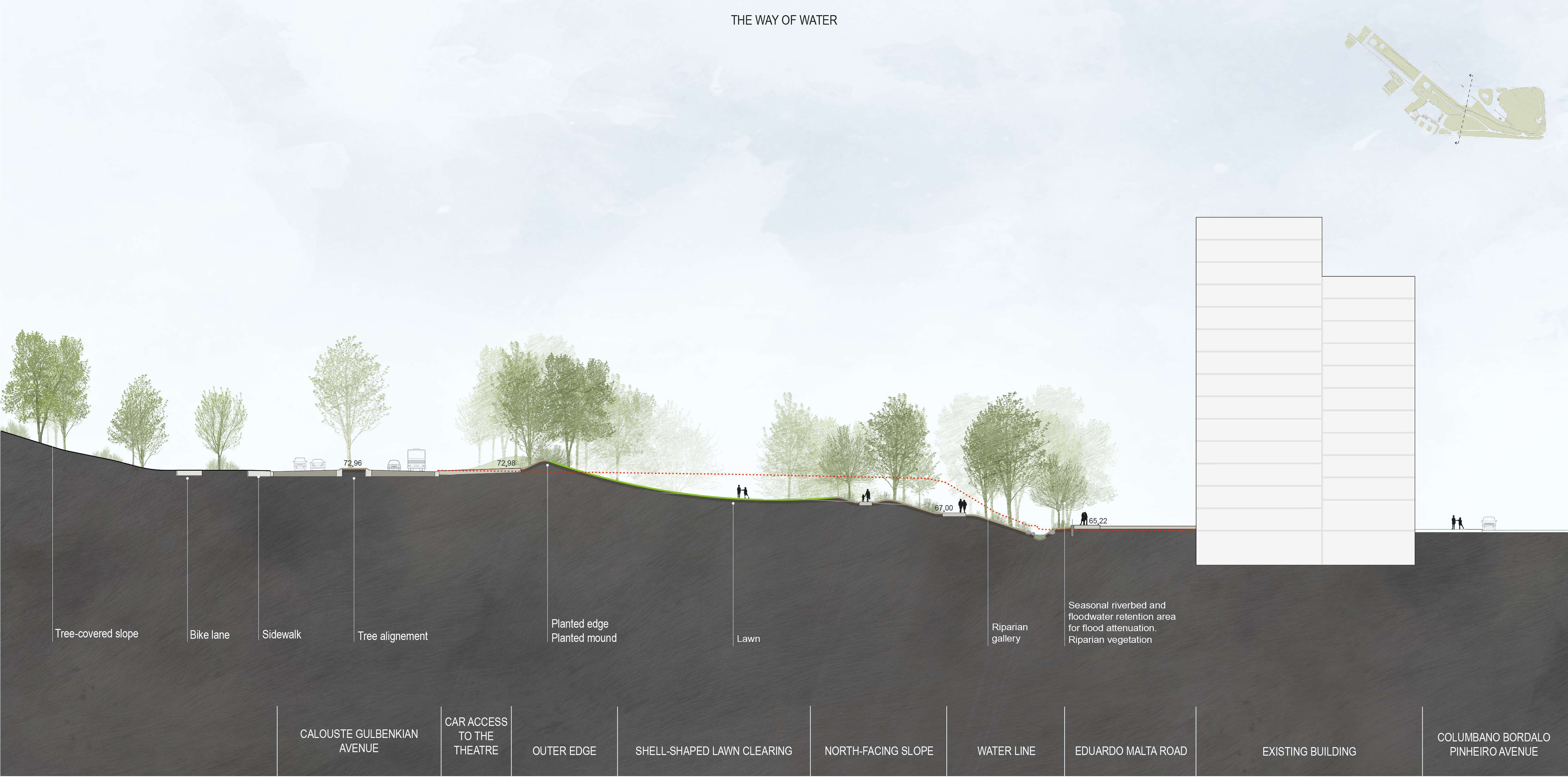
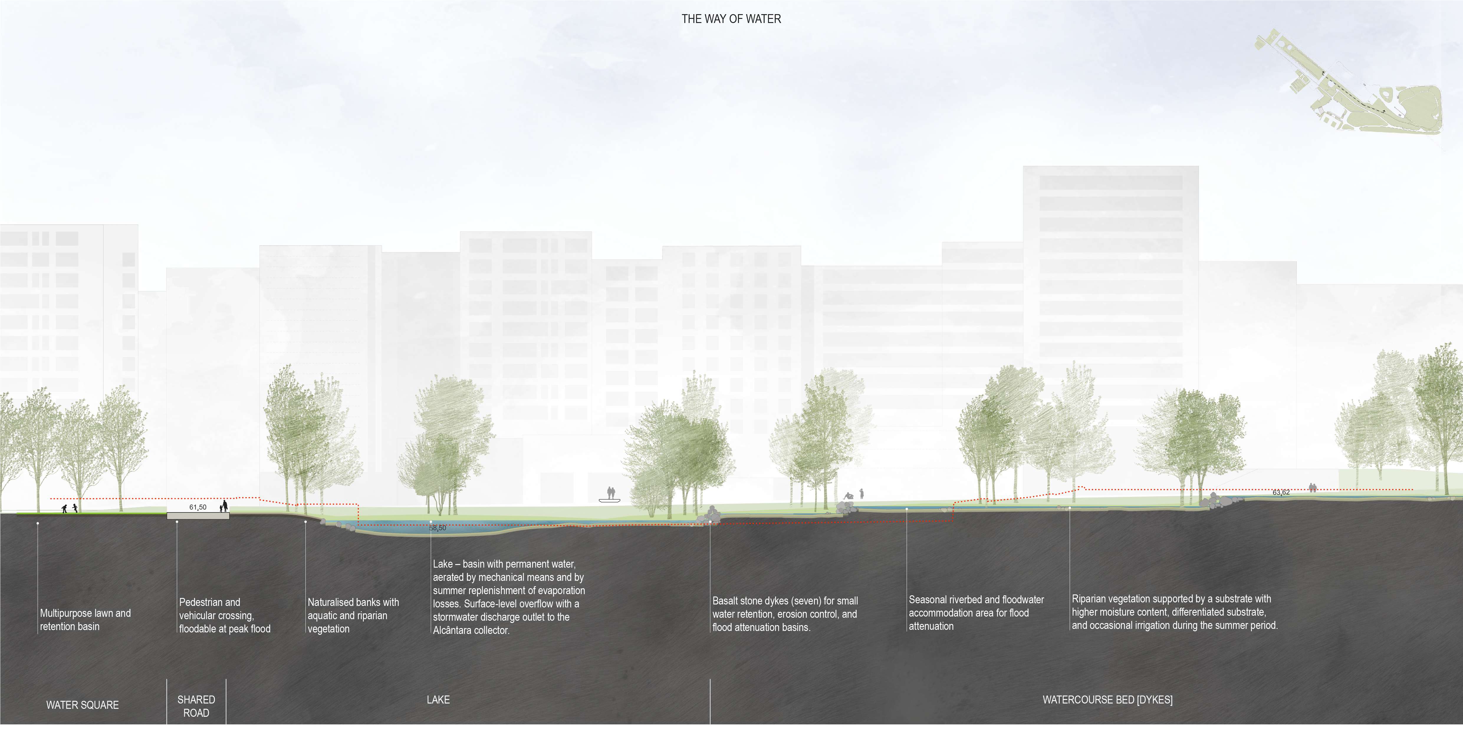
The park is fluid and gentle like the forms water assumes; surfaces are moulded, in elevation or depression, to control water and to define and compartmentalise spaces.
Whilst controlling runoff and retarding rainwater flows, favouring their accumulation, slow release and infiltration, the relationship between spaces is managed, enclosing and isolating the park from surrounding roads, creating clearings and edges, revealing and making the watercourse more accessible.
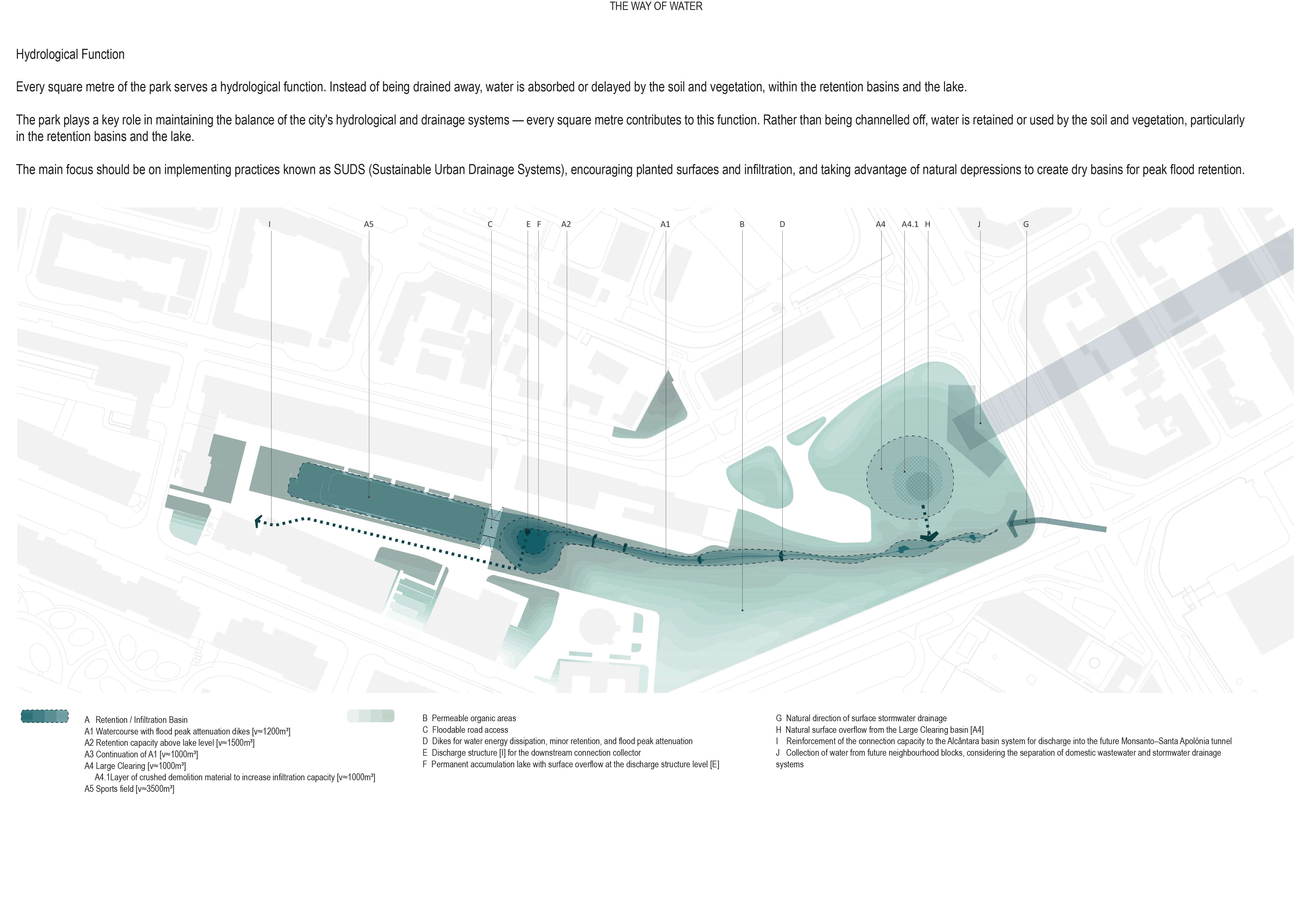
Hydrological Solution
Every square metre of the park has a hydrological function. Instead of diverting water away, it is utilised or retarded by soil and vegetation, in retention basins and in the lake.
In adapting to climate change and defending against floods, refusing the construction of underground reservoirs; on the contrary, channelling effort into Sustainable Urban Drainage Systems (SUDS):
• Creating depressions and levees for retention and flood peak lamination;
• Infiltration of surface runoff;
• Increasing planted surfaces;
• Sub-base of the great clearing constructed with 1,000m³ of crushed material, utilised from demolitions, to expand retention and infiltration capacity;
• Minimising paved surfaces and opting for permeable pavements;
Renaturalising and optimising the strongly marked thalweg line in the designed solution, so as to infiltrate all water falling in the park and still accommodate runoff water from the surrounding urban space, reducing floods at the city's lowest points.
Mobility Solution
The park promotes and facilitates soft mobility and public transport; the central square is a transport interface location, including Metro access, and pedestrian orientation between various quadrants. The proposal integrates into the city's soft mobility network, amplifying it and establishing new pedestrian and cycling connections.
Built Solution (Cafeteria and Kiosks)
A canopy system resolves the programme, creating, beyond a new identity, reception and meeting areas near Metro entrances, a café with terrace and remaining support areas such as public toilets and technical storage.
On the Central Square platform, support structures were created and flow and stay systems reorganised. The existence of underground infrastructure belonging to Lisbon Metro establishes the implementation area to avoid waterproofing areas capable of being renaturalised.
The interplay of materialities, the contrast of pigmented concrete with the delicacy of reflective areas, allows a balance between matter and light, creating ambiguous and logically impossible environments. The reflections, through their strategic location, transport the park into the Metro entrances and mimic nature on opaque surfaces that one wishes to suppress. These horizontal platforms, beyond providing shade, are also rainwater collectors that will be channelled for infiltration in the Park.
The built programme extended to two other small satellites - kiosks located at other points in the park to equally serve and support the use of those places.
Tree Solution
Preserving existing trees whilst expanding already established masses, emphasising the dichotomy between humid gallery and temperate edges.
This location holds important tree wealth that the solution preserves: Portuguese oaks, cork oaks, wild olives, black and white poplars, lime trees, plane trees and plum trees.
The definition of the tree stratum distinguishes two systems corresponding to two different morphological and hydrological contexts. One associated with watercourse renaturalisation - riparian gallery, more humid and fresh - and another more associated with exterior edges, drier, a mixed woodland with dominant presence of Portuguese oak and wild olive, but also integrating deciduous species such as maples, wild pears and wild cherries. The distinction between the two stems from the park's morphology: the riparian gallery on the main thalweg margins, giving body to the stream, and the mixed woodland around the park's perimeter, giving continuity to the Gulbenkian edges.
The strategy is to insist on native species because they present the greatest resilience in our territory. But using isolated native species is insufficient; we want to constitute potential associations between plants of various strata - arboreal, shrub and herbaceous - to thus exponentially increase positive interactions that the ensemble can generate.
Shrub Solution
The shrub stratum is the great builder of garden compartmentalisation, constructing perspective and surprise that determines our imagination.
The shrub stratum was the great builder of the park's compartmentalisation, promoting place distinction, constructing depth and perspective through the complexity of planes that add to the gaze and through the surprise they determine, making us imagine and expand space.
An edge sustained by a diverse cast of shrubs marks the perimeter and protects the interior from the exterior roadway. This edge is also essential in constituting biodiversity corridors that promote the appearance of other plants and fauna.
Herbaceous Solution
The lowest strata were essential for the park's construction. On one hand, through constituting strategically placed grass clearings to expand the park's carrying capacity; on the other, through creating biodiverse meadows that foster natural spontaneity and insects essential to the entire ecosystem's balance.
For creating biodiverse meadows, a group was formed between the design team, the Higher Institute of Agronomy (ISA) and the private company Semente de Portugal to create various plant lists that were sown, entirely native. For one year, herbaceous and bulb seeds were collected from various places in the Lisbon region, to then establish the seed beds that today populate the park.
Material Solution
All inert construction used the location's geological substrate - basalt - as its base. Basalt, absent from the city's construction lexicon for many decades, returned to be experimented with and worked, to construct all pavements, walls, benches and buildings.
Lisbon's volcanic substrate, after being abandoned for construction purposes in the city of Lisbon for many decades. Geological stratum: Research/revive retaining wall construction practices.
National Urban Rehabilitation Award 2025
Honourable Mention Valmor Prize 2023
Visão Verde / Águas de Portugal Award 2023 in the "Water and Sustainable Cities" category
Flagship Project for Lisbon, European Green Capital 2020
The Gonçalo Ribeiro Telles Park project addresses five Sustainable Development Goals, which are: SDG 3 (Good health and well-being), SDG 6 (Clean water and sanitation), SDG 11 (Sustainable cities and communities), SDG 13 (Climate action), and SDG 15 (Life on land).